Buran Ghati Trek Itinerary.

Description
.Meals Included
.Guide
| 7 Days | 6 Nights |
Day 1 - Heading to the Janglik Base Camp (9,200 ft)
- Start from Shimla at 06:30 AM and take a 6-hour long journey to enjoy the Buran Ghati trek .
- Pick up vehicles will be arranged to leave from Shimla.
- Transportation is available on additional charges
- The base camp of this Buran Ghati trek is Janglik. Diude is the closest road head to Janglik.
- From Rohru to Diude, you will get to see the beautiful Pabbar river.
- Watch the square wheat fields along the river and beautiful Himachali homes. The road climbs alongside pretty villages and mixed forests until it gets to the pine forests.
- Go through the motorable road at Tikri, just after Chirgaon, it turns left and becomes an absolute dirt track for the rest of the way.
- It takes two hours along the dirt track to get to Tonglu.
- At Tonglu, the dirt track drops down to the river, crosses the Pabbar and climbs to Diude in swift switchbacks. Janglik is a short walk from Diude.
Day 2 - Diude/Janglik to Dayara Thach (9,200 ft to 11,075 ft)
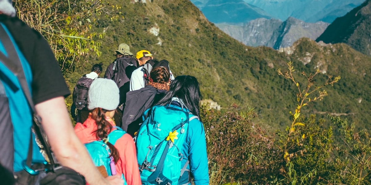
- Make your way to an ascent into a forest for about 30 minutes followed by a gradual descent for about an hour in the meadows ending with a gradual ascent through a forest.
- Come out of Janglik and witness the beautifully crafted wheat fields lined by charming wooden farmhouses on their edges.
- Within fifteen minutes, you will leave the last huts of quaint village behind your trail. Then start climbing the altitudes rapidly.
- In an hour, you will come to step on a ledge and then give your eyes the splendid views of janglik, Tonglu and other villages.
- The ledge under a pine tree is a wonderful place to take a break.
- Fifteen minutes later, past a clearing on your right, the trail climbs into an oak and pine forest.
- Follow the steep trail that levels off to a gradual, pleasant climb.
- Half an hour later, you will escape from the tree line into a vast expanse of meadows climbing into the hills to your left.
- The trail out of the tree line descends gradually, skirting the top of the pines. The trail is well defined and broad.
- Almost an hour later, the trail enters another magnificent forest of pine and oak but thicker.
- Through the forest, the trail climbs gradually before popping out of it again in another half hour.
- Watch the perfectly landscaped meadows of Dayara in front.
- Camp at Dayara.
Day 3 - Dayara to Litham (11,075 ft to 11,737 ft)
- Today's trek starts with a gentle ascent for about 15 minutes followed by a stream crossing.
- Ascend through a pine forest and meadows for about an hour followed by a gentle descent through a silver birch forest and meadows.
- You will not require a refill today if you carry 2 liters of water from Dayara. Find streams on the trail.
- The trail from Dayara to Litham will show you some of the dense forests, wide green meadows, gushing streams, and brooks as you cover an altitude of 740 feet in 3 hours.
- The trail goes through the meadows towards the Gunas Pass.
- A gently ascending trail enters another clump of pine forest fifteen minutes out of the Dayara campsite.
- Then you get to a stream that needs to leap over.
- Across the stream, the trail climbs out of the forest and rounds a wide curve to regain the views of the snow-capped mountains of the Dhauladhar range and Gunas Pass.
- Behind the pine forest, you will see the snow-lined cliffs.
- Half an hour later the trail will come to a forest full of silver birch. The forest is old and the silver birches gnarled with age.
- Descending gently through the forest leads to another perennial stream in the fold of the mountain.
- Refresh here and climb out of the fold to your first clear view of Litham.
- Across the meadows, the trail dips to the Chandranahan stream that you need to cross before throwing down your backpacks at the Litham campsite.
- Enjoy the views of the snout of the Chandranahan waterfall, beyond which is the Chandranahan lake.
- In front are the towering snow-clad mountains that hide Buran Ghati but set the heart fluttering in anticipation of a great adventure ahead.
- On the right are the snow patched cliffs that hide the Rupin valley.
- Stay overnight at Litham campsite.
Day 4 - Excursion to Chandranahan lake (11,737 ft to 13,900 ft and back)
- The Chandranahan lake is a glacial tarn that is perennially fed by snow flanks of mountains that surround it.
- Cross the stream that you get just before the Litham campsite.
- Continue upstream on the shepherd’s trail to a ridge top.
- Walk towards the snout of the waterfall from where the stream emerges.
- It takes about an hour and a half to get to the snout of the waterfall, marked by beautifully placed stone cairns.
- The journey to the lake takes a difficult turn the moment you get to the flat at the snout of the waterfall.
- In late June, the valley floor has good amounts of snow but nothing that is difficult to walk on.
- There are tiny waterfalls that turn into brooks that trickle down to the lake from all sides.
- Spend time taking in the sights of the setting before heading back to Litham the way you came.
- It is a steep descent from the lake to Litham. You must start early in the morning to be back at Litham at lunch.
Day 5 - Litham to Nalabansh (11,737 ft to 13,365 ft)
- Buran Pass trek can be easy or difficult depending on where you camp for the passing assault.
- Nalabansh at 13,000 ft is a perfect and short two-hour climb to the pass.
- The Dhauladhar range looms over the trail with the Gunas pass sitting pretty on top of the snowy flanks of the grey mountains.
- It is a monochrome setting of grey and white in front, with the green grasslands of Litham to the left, and cliffs of the bordering Rupin valley to the right.
- Climb this adventurous trail covered in snow, this will be a remarkable experience for you.
- Continue up the left bank until the trail gets into a U-shaped gorge-like valley and you get the first view of the Buran Ghati on your left.
- Start the climb to Nalabansh by following the well-marked shepherds’ trail that leads in the general direction of the pass.
- After an hour of climb, you will reach the ridge top of Nalabansh.
- Get the awesome views of Buran Ghati and the trail that leads to it.
- The camp is in an alpine zone. Snow-capped mountains flank the campsite on all sides.
Day 6 - Nalabansh to Munirang (13,365 ft to 11,800 ft via Buran Ghati)
- Follow the ridge and hop over boulders towards the base of the pass.
- From the base it is an hour long climb to the top, mostly on snow.
- Buran Ghati is at exactly 15,000 ft and offers a thrilling climb.
- It is a narrow ledge on the top.
- The drop on the other side is sharp and steep.
- Without the rope, the descent can be risky even with an ice axe.
- Getting down to the first snow field about 100 metres below the pass is your first objective.
- Thereafter it is a series of descents over smaller ledges that you can slide down.
- Descending on the Buran Ghati trek is quick and very soon you lose all the altitude that you have gained.
- It takes about 2 hours to get to the end of the snow line.
- You also lose about 3,000 ft in altitude.
- Out of the snow line, the descent takes you down a ridge with junipers and lovely flower crested shrubs.
- The view of the valley in front is lush green as far as the eye can see.
- Beyond, a long range of mountains tower over the setting.
- Descend for another hour to get to a stream that needs to be hopped over.
- Across the stream the first farmers’ huts appear. You camp here for the night.
Day 7 - Munirang to Brua Village(11,800 ft to 6,700 ft)
- The descent to the Barua village is remarkable for the variety in vegetation and diversity.
- Take the path that follows the Barua Khud.
- Stick to the trail that is broadest and most used.
- The trail descends rapidly through the high altitude pines, giving way to a mix of other trees.
- An hour and a half later the trail descends to a large gushing stream meeting the Barua Khud.
- A makeshift bridge lined with junipers and mud is the only way across.
- Climbing out of the stream, the trail is greeted with more diverse vegetation.
- An hour later the first apple orchards and signs of civilization await the trekkers.
- Then the trail enters Barua village through an arch.
- It is a long descent through the village as the trail meanders and descends through.
- Once at the heart of the village, the descent is more rapid.
- In half an hour the trail pops out onto the road bridge over the Barua Khud.

